BaseBubbles

Concept for mobile phone users mapping the city by logging adjacent cell IDs, and building public services on top
Introduction
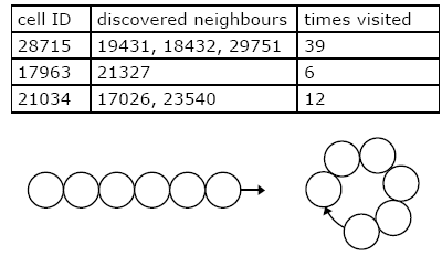
BaseBubbles is based on a very simple idea but the possibilities are numerous. As a user travels inside a GSM network this program would store geographical points visited displaying them on screen as a graph. Every mobile phone has the capability to measure the signal strength to the antenna it is currently connected to. Each antenna covers an area called a cell and each cell has a specific number assigned to it called the cell id. The cells are arranged in a honeycomb pattern where each cell and its corresponding antenna operate at a certain wavelength. The sizes of the cells can vary from no more than a hundred meters in heavy populated areas to several kilometers in the less populated ones. Two cells with the same frequency cannot be adjacent so the cells are arranged in certain patterns to prevent this from happening. A cluster of cells is called a footprint. The cell id is retrieved by the mobile phone and on more advanced models it is possible to retrieve this information from the phone and store it as a variable. BaseBubbles is based on this idea.
Technical Specifications
Every cell a user visits would be stored in a database. When traveling into an adjacent cell this traverse is stored in the database as cross-references and neighboring cells are tied to each other. Traveling into uncharted areas would be displayed graphically as a straight chain of bubbles but as soon as a cell is revisited the chain curves and connects these two bubbles. In this way each bubble is as close to its neighbors as possible.
Possibilities
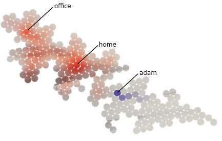
Developing from this simple idea BaseBubbles could grow into numerous things. It would learn a city together with its owner making the BaseBubbles world grow. Each bubble could have the possibility of being named and have comments attached to it. It is the user’s decision whether a bubble should be named or not and what to name it. The number of times a cell is visited could also be stored and displayed with more intense colors for example. Several friends could share their positions by connecting to a shared server on the Internet and combine their worlds into a shared space enabling them to make it grow in many directions at the same time. A user could leave a trace behind showing the path taken and allowing for paths being crossed. User could perhaps engage in instant messaging conversations over the GPRS connection if they find someone in the same bubble.
The Game
From the gaming perspective there are also many possibilities. The BaseBubble world could turn into an arena where the participants defend their bases from intruders. Certain items could be collected in specific bubbles giving each team extra points or similar. The whole game takes place in this self created world. The exact geographical location of the user is not necessary to know.
Concluding
Today there exist many projects developing position-based services for a market that is expected to reach an annual turnover of billions of dollars every year. Common for these new solutions is that the require GPS or more refined mobile positioning systems that are still under development. Our map replaces the somewhat outdated geographical representation of a city much like a subway map that embeds traveling time and key locations. We are already used to navigate after these and BaseBubbles is another step in this direction.


